


Altimeter Multi Pro app for iPhone and iPad
Developer: Web-Dream
First release : 06 Jul 2013
App size: 23.31 Mb
"Altimeter Multi Pro" is probably the most comprehensive and most accurate altimeter of the mobile market. It includes all the functions necessary for hikers and forestry professionals.
Its strengths:
- 3 types of altitude measurements to ensure a perfect precision (GPS - Internet server "ellipsoidal" - Internet server "sea level").
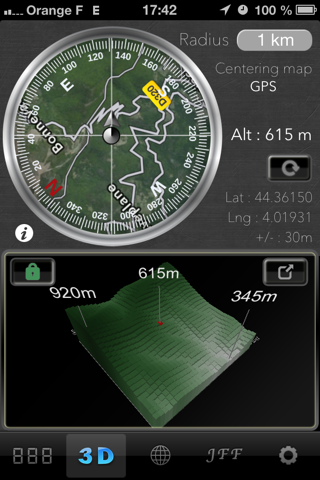
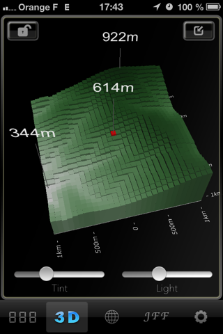
- Visualization of 3D area, to assess the difficulty of the hiking trail.
- Visualization of 2D curves levels (elevation) of any route.
- Function "address search" to know the altitude and to see a 2D or 3D ground anywhere in the world.
Altimeter Multi Pro is equipped with 4 altimeters:
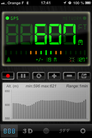
Digital Altimeter:
- Measurement of altitude in meters or feet.
- Altitude measurement provided by GPS or by the Internet Server (NETWORK).
GPS information is provided by the device. The data vary slightly depending on the visible satellites.
Altitude provided by Internet server is unique to a given position. The data refresh occurs when you move a predetermined distance (10, 50, 100 or 500 m / 32.8, 164, 328, 1640 ft).
- In the web server mode (NETWORK), altitude can be supplied with the ellipsoidal earth model or relative to sea level.
Sealevel : Use the geoid Earth model (EGM2008 2.5’).
Ellipsoid: Use the ellipsoid Earth model (WGS84).
- Audible alarm when exceeding a preset altitude (setpoint).
- 2D graphics to visualize the evolution of altitude during your ride (adjustable from 1 min to 24 hours).
- Optimized for use in daylight (sun on the mobile screen).
- Ability to send by email a screenshot (to save an achievement).
- Compass with measurement of the magnetic north or true north. Indication of the angle to the north.
- Display the measurement error of the altitude (in GPS mode).
3D Altimeter
- Measurement of altitude in meters or feet.
- Measurement provided by internet server (NETWORK).
- Ellipsoidal earth model or relative to sea level.
- Visualization of the ground in 3D. The viewing radius is configurable 999km to 50m (164ft to 3277559ft).
Possibility to extend the 3D view and examine under different orientation and zoom. The 3D view shows your altitude and the minimum and maximum elevation in the radius.
- True or magnetic compass. Indication of the angle to the north.
- With the "Address Search" you can view a 3D terrain anywhere in the world.
"Curves Levels" Altimeter
- Measurement of altitude in meters or feet.
- Measurement provided by Internet server (NETWORK).
- 2D visualization of vertical drop of a course anywhere in the world (address search).
- Flags Steps are captured easily with the finger. The flags can be moved or deleted easily.
"Just For Fun" Altimeter
Just 10 original and elegant altimeters, for your viewing pleasure.
In all modes, the maps can be viewed in satellite mode, Satellite+map, map.
Multilingual application: English - French
Compatible with : iPhone 4, iPhone 4S, Iphone 5, Ipad - Retina ready